
Convert one location between decimal degrees, DMS, DDM, and UTM with clear checks for order, signs, hemisphere, and WGS84 zone details.
Advanced options
How to use our Coordinates Converter Calculator
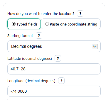
- Choose how you want to enter the location in How do you want to enter the location?, then pick the Starting format you already have.
- If you use typed fields, fill only the visible rows for that format, such as Latitude (decimal degrees) and Longitude (decimal degrees) or the DMS, DDM, or UTM fields. If you paste, enter the full location in Coordinate text.
- Open Advanced options if needed to set Decimal places to show, choose Expected coordinate order in pasted text, or turn Show precision note on or off.
- Click Calculate, then read the converted values in Decimal degrees, Degrees, minutes, seconds, Degrees and decimal minutes, and UTM coordinates.
- Sanity-check the result before copying it: make sure Check this before using the result shows no problem, and confirm the UTM zone summary matches the place you expected.
Definitions
Decimal degrees: Latitude and longitude written as signed decimals, such as 40.7128 and -74.0060. This is the most common format for web maps.
Latitude: North-south position on Earth. Valid values run from -90 to 90 degrees.
Longitude: East-west position on Earth. Valid values run from -180 to 180 degrees.
DMS: Degrees, minutes, seconds. One degree is 60 minutes, and one minute is 60 seconds.
DDM: Degrees and decimal minutes. This keeps whole degrees and puts the smaller part into minutes with decimals.
Hemisphere: The letter that shows direction: N or S for latitude, and E or W for longitude.
UTM zone: One of 60 longitude bands used by the Universal Transverse Mercator grid. The zone number helps place the coordinate in the correct east-west strip.
Easting and northing: UTM grid distances in meters. Easting measures east-west position in a zone, and northing measures north-south position.
WGS84: A standard Earth reference system used by GPS and many mapping tools.
Common mistakes and quick fixes
Mistake: Typing west longitude as a positive number in Longitude (decimal degrees) .
Fix: Use a minus sign for west, such as -74.0060, because positive longitude means east.
Mistake: Entering negative numbers in Latitude degrees (deg) or Longitude degrees (deg) while also choosing Latitude hemisphere or Longitude hemisphere .
Fix: Keep degrees nonnegative in DMS or DDM entry and let the hemisphere dropdown supply the sign.
Mistake: Putting 60 or more into Latitude minutes (min) , Longitude minutes (min) , Latitude seconds (sec) , or Longitude seconds (sec) .
Fix: Minutes and seconds must be at least 0 and less than 60. Carry extra amount into the next larger unit.
Mistake: Pasting longitude first into Coordinate text when Expected coordinate order in pasted text is set for latitude first.
Fix: Change the order setting or rewrite the pasted pair so it matches the chosen order.
Mistake: Leaving out the zone or hemisphere when using UTM and then trusting UTM coordinates or UTM zone summary without checking.
Fix: For UTM input, enter UTM zone (1-60) , UTM hemisphere , UTM easting (m) , and UTM northing (m) exactly as given by your source.
Mistake: Assuming more digits in Decimal degrees always mean a more accurate real-world location.
Fix: Use Decimal places to show for display only, and read Precision note to judge how much ground detail the shown digits represent.
Limitations & Key Assumptions / Boundary Conditions
- The calculator converts one location at a time and is designed for WGS84 coordinates only.
- UTM results depend on the correct zone and hemisphere. Near a zone boundary, compare the UTM zone summary with your source before sharing the result.
- Standard UTM is not meant for the polar regions, so locations outside normal UTM latitude coverage should be treated with caution.
- The Decimal places to show setting changes display precision, not the true accuracy of your original source.
- Pasted text can still be ambiguous when both numbers could be valid latitudes or when the source omits clear separators or hemisphere clues.
- Rounded DMS or DDM output may look slightly different from another tool if that tool uses a different rounding rule or number of shown decimals.
Methodology
How the converter works
The calculator first turns the starting format into one internal latitude-longitude pair in decimal degrees on WGS84. After that, it formats the same location into all output styles.
Core formulas
decimal degrees = sign x (degrees + minutes / 60 + seconds / 3600)
absolute decimal degrees = abs(decimal degrees)
degrees = floor(absolute decimal degrees)
minutes full = (absolute decimal degrees - degrees) x 60
minutes = floor(minutes full)
seconds = (minutes full - minutes) x 60
decimal minutes = (absolute decimal degrees - degrees) x 60
UTM zone = floor((longitude + 180) / 6) + 1
central meridian in degrees = zone x 6 - 183
UTM conversion on WGS84
For UTM output, the calculator uses the standard Transverse Mercator forward equations on the WGS84 ellipsoid with semi-major axis 6378137 m, flattening 1/298.257223563, scale factor 0.9996, false easting 500000 m, and false northing 10000000 m in the southern hemisphere. For UTM input, it applies the matching inverse equations to recover latitude and longitude.
Worked mini-example
Suppose you enter 40 degrees, 42 minutes, 46.08 seconds north and 74 degrees, 0 minutes, 21.6 seconds west.
latitude = +1 x (40 + 42 / 60 + 46.08 / 3600) = 40.7128
longitude = -1 x (74 + 0 / 60 + 21.6 / 3600) = -74.006
That decimal pair can then be shown as DD, DMS, DDM, and UTM. For longitude -74.006, the UTM zone formula gives zone 18.
Validation and warning logic
The calculator blocks values outside latitude -90 to 90 and longitude -180 to 180. In DMS or DDM entry, minutes and seconds must be at least 0 and less than 60, and degree fields must stay nonnegative because hemisphere sets the sign. If pasted text mixes a minus sign with an opposite hemisphere letter, the calculator shows an error instead of guessing. It also warns when a pasted pair looks reversed or when the order is still ambiguous.
Precision note
The optional precision note estimates the ground size represented by the last shown decimal place in decimal degrees. It is a display guide, not a promise of GPS or source accuracy, because real accuracy also depends on the original measurement and rounding.
Assumptions behind the results
The results assume WGS84, standard UTM equations, and a single point location. Small differences from other tools can happen because of rounding choices, input order assumptions, or different projection implementations near boundaries.